What to Expect From California, the State That Thinks It's a Continent
Eight hundred miles of desert, alpine range, and temperate coast in one state. The season that suits one part rules out another.
- Flag
-

- ISO code
- US
- Currency
- USD
California covers 163,696 square miles. Drive from the Oregon border to Mexico on Interstate 5 and you cover roughly 800 miles. That is farther than New York City to Chicago, and you never leave one state. This california travel guide exists to warn you, honestly, that the postcard fantasy of surfing at sunrise and skiing at sunset is a logistical lie, but what is real is better if you respect the scale. The state contains nine national parks, twenty national forests, and 280 state parks, each separated by hours of freeway. The friction is real: gas prices often sit $1.50 to $2.00 above the national average, coastal fog called June Gloom can erase ocean views for days straight, and wildfire smoke from July into October closes highways and parks with little notice. You need a car, a budget that accounts for the shock, and a willingness to spend whole days behind the windshield. If that sounds like your kind of trip, California rewards you with the most diverse landscape and food culture in the country, on a scale that makes other states feel like postage stamps.
- Land Area: 163,696 sq mi (423,970 km²)
- North-South Length: Approx. 800 mi (1,290 km) via I-5
- National Parks: 9 wholly or partly within the state
- State Parks: 280 (annual figure, check California State Parks for current count)
- Climatic Zones: 5 per the Köppen classification: Mediterranean, desert, semi-arid, alpine, marine west coast
- Minimum Days Recommended: 10 days. Less forces a choice between one region or a blur of freeway miles.
- Peak Season: June through August. National parks and coastal towns book 6-12 months ahead.
- Avoid Window: Thanksgiving week for airport and freeway chaos; Death Valley and low desert June to early September (daytime highs above 46°C)
California Road Trip Planning: Accept the Distances Now
The single mistake first time california itinerary planners make is treating the state like a compact destination. Los Angeles to San Francisco via the scenic coastal highway, State Route 1, is a 10-hour, 460-mile drive when fully open. That is a full day of driving with no shortcuts. Los Angeles to Yosemite Valley is 310 miles one way, a 5.5 to 7 hour slog depending on traffic across the Central Valley. You do not do both in a week and have any time on the ground. The research is explicit: minimum 10 days, and any less forces you to choose between a single region or a miserable blur of freeway miles.
The second error is not planning for what gets in the way. Tioga Pass, State Route 120 into Yosemite, closes by snow in winter and reopens late spring or early summer. Lassen Volcanic National Park Highway does the same. Landslides on State Route 1 at Mud Creek or Paul's Slide in Big Sur can close the coast for weeks during wet seasons. Cell service vanishes in the High Sierra backcountry, deep canyons, and remote desert parks. Download offline maps. Never rely on streaming navigation on Highway 1 or mountain passes. Carry tire chains in mountain zones from November into April regardless of conditions; chain controls are enforced.
Why You Need A Rental Car
A rental car is non-negotiable outside the core of San Francisco. You need a credit card for the deposit. You also need an electronic toll transponder or an online account for bridge and express lane tolls, because missing a toll payment within 48 hours generates fines that rental companies inflate. Those fast lanes you see on urban freeways are often pay to use. Budget for 197,000 lane miles of public road and 25,800 highway bridges maintained by Caltrans. The fuel tax rate in 2026 is set by the state at $0.596 per gallon of gasoline on top of the highest pump prices in the nation.

What to Know Before Visiting California: the Honest Version
What to know before visiting California: the postcard omits the cost and the crowds. Overnight accommodation inside Yosemite, Big Sur, and coastal state parks often books solid 6 to 12 months ahead. Parking at popular trailheads and beaches fills by 7:00 AM on weekends. A forgettable motel room in peak season runs $200 plus per night. The state sales tax base rate is 6.00 percent in 2026, but local add-ons push it as high as 8.50 percent depending on the city. Nothing on the menu costs what the menu says.
Yet the return is unmatched. You can stand in the lowest point in North America at Badwater Basin in Death Valley at 282 feet below sea level and drive five hours to the highest point in the contiguous United States at Mount Whitney at 14,505 feet. You can eat a mission style burrito wrapped in foil in San Francisco, then drive south and eat fish tacos in San Diego shaped by Baja influence, beer battered white fish with shredded cabbage and crema. You can taste an $18 avocado toast born from the wellness breakfast culture that started here. No other state offers this range.
The Weather You Actually Get
Coastal regions peak late spring into early autumn: drier, warmer. But the marine layer called May Gray or June Gloom can sit for days, dropping temperatures and erasing views. The North Coast runs even cooler; water temperatures off Crescent City range from 48°F in winter to 58°F in late summer. Surfers wear wetsuits year round. Desert regions peak in the cooler months of late autumn into early spring; summer is the avoidance period for extreme heat. Death Valley and the low desert routinely exceed 46°C from June to early September. The Sierra Nevada high country is snow free and accessible in summer into early autumn; winter into mid spring is the avoidance period due to heavy snow and road closures. The Sierra Nevada receives 100 inches of snow at lower elevations and over 500 inches at the highest.
| Region | Character | Best For | Avoid If |
|---|---|---|---|
| North Coast | Redwood cathedrals, fog, empty wild beaches | Hikers who want solitude among the tallest trees on Earth | You need sun and warm ocean water |
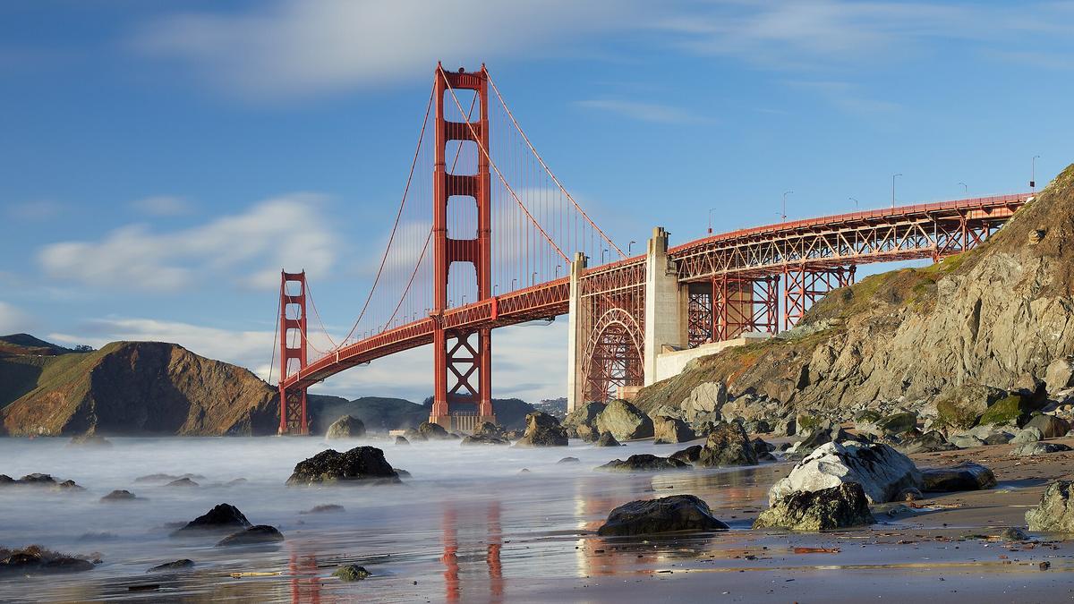
| San Francisco Bay Area | Tech wealth, microclimates, steep hills, Golden Gate Bridge | Urban explorers with deep budgets who like walkable pockets | You hate paying $10 for a coffee and need easy parking |
| Central Coast | Cliffs, elephant seals, Hearst Castle, Big Sur coastline | Road trippers who genuinely love long coastal drives | You are prone to motion sickness on cliff edge highways |
| High Sierra | Granite domes, alpine lakes, high elevation hiking | Backpackers and climbers chasing Yosemite Valley and Sequoia | You want resort amenities without the drive |
| Los Angeles Basin | Sprawl, global food, industry glamour and grit | Food and wine pilgrims with deep budgets, theme park families | Budget backpackers relying on public transit |
| Deserts | Joshua Tree boulders, mid century modern, stark heat | Rock climbers and photographers in the cool season | Anyone visiting between June and September |
| Shasta Cascade | Volcanic peaks, lakes, near empty highways | Road trippers avoiding crowds entirely | You need services every 20 miles |
| San Diego County | Polished beaches, craft beer, borderland culture | Families and surfers who want reliable weather and Mexican day trips | You want gritty urban energy and late night clubs |
First Time California Itinerary: How to Build 10 Days That Work
A first time California itinerary needs a thesis. You cannot do everything, so pick the two regions that match your reason for coming and drive between them on the fastest route, not the prettiest one. Los Angeles to San Francisco via I-5 takes 5.5 to 7 hours; via State Route 1 takes 10 hours. Use the fast route for repositioning and save the coast for when you have time to stop overnight. The Amtrak Coast Starlight between Los Angeles and Seattle is an alternative if you want to look at the ocean without driving, but you still need a car on either end.
If You Want The Parks
Fly into San Francisco. Drive 3.5 to 5 hours to Yosemite Valley. Book your Yosemite accommodation 6 to 12 months ahead; summer reservations are required inside the valley. Then drive east on US 395 along the Eastern Sierra, past Mono Lake, and head up to Lake Tahoe. That route alone eats five days. Add a day at Redwood National and State Parks up the North Coast, which is a 315 mile drive from San Francisco that takes a full day each way. You do not add Death Valley and Sequoia in the same trip unless you have two weeks.
If You Want The Coast And Food
Fly into Los Angeles. Spend two days on the global food scene, then drive 120 miles down I-5 to San Diego, a 2 to 3.5 hour trip. Use San Diego as a base for Balboa Park, the craft beer corridor, and a day trip walking across the border at San Ysidro into Tijuana, which takes 20 minutes with a passport. Then drive north on Amtrak's Pacific Surfliner or by car back through Orange County to Los Angeles. This loop is manageable in 8 to 10 days. Do not add the Central Coast unless you have time for the 2.5 hour Amtrak Pacific Surfliner ride to Santa Barbara or a 1.5 hour drive north.
Entry And Arrival
Eleven international airports serve scheduled passenger service. Los Angeles International Airport is the busiest entry. Take the LAX FlyAway bus to Union Station for $9.75, a 45 to 60 minute trip. A rideshare to Hollywood or Santa Monica runs $45 to $70, 35 to 60 minutes. San Francisco International connects to downtown via BART train for $10.55, 30 minutes. San Diego International is a 10 minute cab or rideshare to downtown for $15 to $25.
,_Yosemite_Valley_--_2012_--_4661.jpg)
California is for You If You Love the Drive. Skip it If You Do Not.
This state suits road trippers who genuinely love long drives, nature obsessives chasing specific biomes from desert to alpine, food and wine pilgrims with deep budgets, families doing a greatest hits loop of theme parks and beaches, and surfers willing to wear a wetsuit year round. The Pacific Ocean off San Francisco ranges from 50°F in winter to 60°F in late summer. Off San Diego it hits 72°F in late summer. You wear neoprene everywhere north of Point Conception.
California is not for budget backpackers relying on public transit. It is not for anyone who hates driving or sitting in a car for hours. It is not for travellers seeking compact walkable cities with old world charm. Skip it if you cannot stomach spending $200 plus per night on a forgettable motel room in peak season. Skip it if the idea of a 10 hour drive from San Francisco to Los Angeles on State Route 1 sounds like a waste of a day rather than the point of the trip. The scale is the feature, not the bug. Respect the distances, budget for the friction, and California delivers extraordinary natural beauty and world class food that no other state can match.
Common Questions
Is California safe for tourists?
California is generally safe for tourists. Standard urban precautions apply in Los Angeles, San Francisco, and Oakland. The greater risks are environmental: wildfire smoke from July into October, extreme heat in the deserts from June to September, and tsunami hazard zones along the entire Pacific coast. Download the Cal OES MyShake app for earthquake alerts. The state has a hands free law for drivers that has been in effect since July 2008 and motorcycle lane splitting is legal.
When is the best time to visit California for a road trip?
Late spring (May) and early autumn (September to October) offer the best balance of weather and crowd levels. Peak season is June through August, driven by school holidays. The Sierra Nevada is only snow free in summer into early autumn. The deserts are only comfortable in late autumn into early spring. Coastal fog called May Gray and June Gloom can obscure views in late spring and early summer. Wildfire season is most active from late summer into autumn, peaking in September and October.
Do I need a car in California?
Outside the core of San Francisco, yes. A rental car is non-negotiable. You need a credit card for the deposit and an electronic toll transponder or online account for bridge and express lane tolls. The state has 197,000 lane miles of public road. Winter chain controls are enforced on Sierra Nevada passes from November into April regardless of conditions. Gas prices are among the highest in the nation, often $1.50 to $2.00 above the national average.
How many days do I need for a California road trip?
Minimum 10 days. Any less forces you to choose between a single region or a miserable blur of freeway miles. Driving from San Francisco to Los Angeles via the scenic coast is a 10 hour, 460 mile slog. Los Angeles to Yosemite Valley is a 5.5 to 7 hour drive each way. The research is explicit: you do not cover three regions in a week comfortably.
What is the cheapest time to visit California?
Late autumn (November, excluding Thanksgiving week) and winter (December to February, excluding holiday periods) offer lower accommodation prices outside ski areas. Coastal regions experience rain and storm surge in winter. Many Sierra Nevada roads close during this period, including Tioga Pass and the Lassen Volcanic National Park Highway. Avoid the Thanksgiving week in late November for crushing airport chaos and freeway gridlock.
What are the essential landmarks in California?
Yosemite Valley for granite walls and waterfalls (summer reservation required). Redwood National and State Parks for the tallest trees on Earth. Lake Tahoe for alpine clarity. Death Valley National Park for salt flats and extreme heat. The Golden Gate Bridge best seen from the Marin Headlands. Alcatraz Island ferry tickets must be booked weeks in advance. Joshua Tree National Park has no water available on site. Disneyland requires a park reservation plus a ticket. Sequoia National Park requires high elevation access.
Can I visit multiple national parks in one trip?
Not comfortably in less than two weeks. Sequoia and Kings Canyon share a single entrance complex. Yosemite is a 5.5 hour drive from Sequoia. Redwood National and State Parks are a 315 mile drive from San Francisco. Death Valley is a 290 mile drive from Los Angeles. Lassen Volcanic National Park sits in the isolated Shasta Cascade region. Grouping more than two in a single 10 day itinerary produces a miserable blur of freeway miles.
Read next
-
 Best Time to Visit California When One Season Cannot Cover the Whole State
California spans desert, alpine range, and temperate coast. The season that suits Yosemite rules out Death Valley.
Best Time to Visit California When One Season Cannot Cover the Whole State
California spans desert, alpine range, and temperate coast. The season that suits Yosemite rules out Death Valley.
-
 Getting Around California Without Losing Half Your Trip to the Freeway
A rental car is non-negotiable outside San Francisco. Here is how tolls, deposits, and the real driving distances work before you end up with a fine or a
Getting Around California Without Losing Half Your Trip to the Freeway
A rental car is non-negotiable outside San Francisco. Here is how tolls, deposits, and the real driving distances work before you end up with a fine or a
-
 Staying Safe in California From Wildfire Closures to Car Break-Ins
A San Francisco driver returns to their rented SUV in a SOMA parking lot to find the rear window smashed and an empty space where a duffel bag sat.
Staying Safe in California From Wildfire Closures to Car Break-Ins
A San Francisco driver returns to their rented SUV in a SOMA parking lot to find the rear window smashed and an empty space where a duffel bag sat.
-
 What a California Trip Costs in Real Terms Beyond the Sticker Price
California costs more than it looks online. Gas runs well above the national average, peak-season motels top $200 a night, and park lodges book out months
What a California Trip Costs in Real Terms Beyond the Sticker Price
California costs more than it looks online. Gas runs well above the national average, peak-season motels top $200 a night, and park lodges book out months
-
 United States Travel Guide for First-Timers Who Want the Real Picture
The United States delivers extraordinary geographic and cultural variety, but its sheer scale, car dependency, and tipping economy surprise first-timers. Start here.
United States Travel Guide for First-Timers Who Want the Real Picture
The United States delivers extraordinary geographic and cultural variety, but its sheer scale, car dependency, and tipping economy surprise first-timers. Start here.
-
 Staying Connected While Traveling Through the United States
Prepaid eSIMs work well in US cities, but a physical T-Mobile or AT&T SIM bought at arrival gives better rural coverage for national parks and long highway drives.
Staying Connected While Traveling Through the United States
Prepaid eSIMs work well in US cities, but a physical T-Mobile or AT&T SIM bought at arrival gives better rural coverage for national parks and long highway drives.
-
 Best Time to Visit the United States by Region and Season
The United States spans so many climates that no single season works everywhere. Here is what each region delivers, and when to stay away.
Best Time to Visit the United States by Region and Season
The United States spans so many climates that no single season works everywhere. Here is what each region delivers, and when to stay away.
-
 Getting Around the United States Without Underestimating the Distances
Outside the Northeast Corridor, the United States runs on cars and domestic flights. Distances are enormous and Amtrak is scenic but slow.
Getting Around the United States Without Underestimating the Distances
Outside the Northeast Corridor, the United States runs on cars and domestic flights. Distances are enormous and Amtrak is scenic but slow.
-
 How to Budget a Trip Based on Purchasing Power, Not Just Exchange Rates
Exchange rates tell only half the story. See how purchasing power shapes your real travel budget across Southeast Asia, Eastern Europe, and Latin America.
How to Budget a Trip Based on Purchasing Power, Not Just Exchange Rates
Exchange rates tell only half the story. See how purchasing power shapes your real travel budget across Southeast Asia, Eastern Europe, and Latin America.